
Database and GIS Department
The main activity of the Database and GIS Department is the development, management and maintenance of databases in accordance with the latest technologies and modern world practice. As part of the regular activities of the department, data on various thematic units is collected, updated, controlled, verified and analyzed, with a specialized database formed for each unit. In order to meet user needs for data and automate business processes, WEB application solutions for viewing and manipulating data and automatically generating reports are being developed and improved. And The department also analyzes and processes data using specialized software, based on which reports on traffic flows, spatial and temporal distribution of traffic accidents are created, data on functional characteristics of the roadway, road facilities on the state road network are displayed, etc.
The activities of the Department for Data Bases and GIS are based on the provisions of the Law on Public Roads and the obligation of road managers to keep records of public roads and traffic and technical data for roads.
The Department has developed specialized databases on roads, traffic counting, road facilities and objects, traffic signaling and equipment, level crossings, traffic accidents, as well as a central geospatial database containing the most important data from specialized databases and other data.
The Database and GIS Department is working on the development and management of the following databases and accompanying applicative solutions:
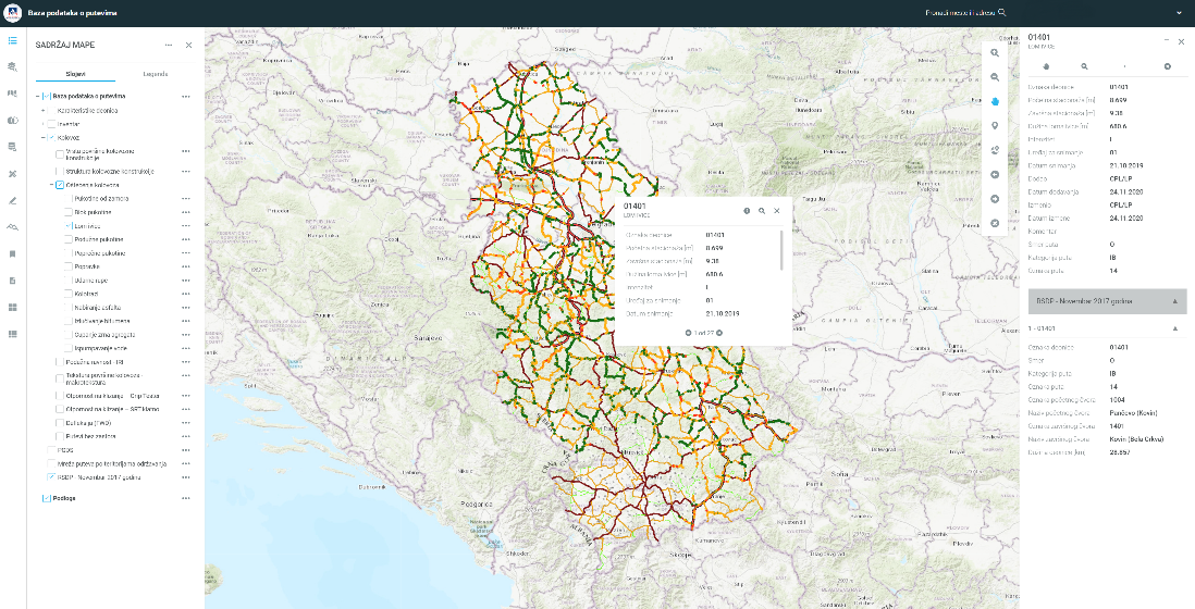
The Road Database contains basic data on state roads of the Republic of Serbia and records and condition of road inventory collected as part of the project "Determining the State Road Network Condition" implemented in 2019/2020. In order to enable users within the PE “Roads of Serbia” to access data from any location and insight into: characteristics of the section, inventory, road condition, traffic flows, state road reference system, etc., a replica of the original database has been created which can be accessed via a WEB GIS application. It is possible to view data on an interactive map, as well as through tables, perform searches and spatial selection and apply other basic GIS tools, as well as export data to various formats.
The Traffic Counting Database contains data on changes in traffic flows over time, i.e. data on traffic flow characteristics such as: average annual daily traffic (AADT), AADT by basic vehicle categories on traffic sections, hourly distribution of traffic flows at 8760 hours during the year, distribution of hourly flows by directions during the year, total monthly traffic, average monthly daily traffic, maximum and minimum daily traffic, total and average night traffic. Automatic traffic counting devices "QLTC-10" have been installed on sections of state roads, which detect and classify vehicles using inductive loops integrated into the road structure. Data from the devices are directly stored in a specialized traffic counting database. Based on the collected data, processing, analysis and reporting on traffic flows are carried out. The presentation of traffic counting data is issued in printed and electronic form, and displayed on the company's website every year.
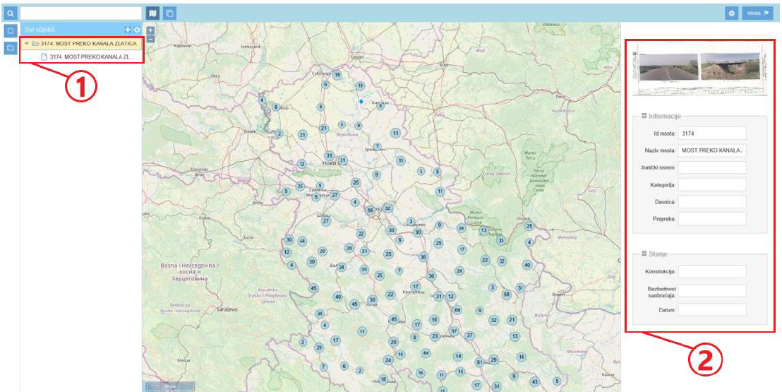
The Road Facilities Database contains data on bridges, tunnels and supporting structures, such as: inventory data and data on the assessment of the condition of elements, requests for special transport, load-bearing capacity check reports, photo documentation, etc. The database data can be viewed via WEB application solutions specially created for all three groups of facilities. In addition to viewing the data, it is possible to assess the condition of the structure of the facility via the WEB application. The database contains data from expert inspections of road facilities and projects of newly constructed facilities that are submitted to the Road Manager for maintenance.
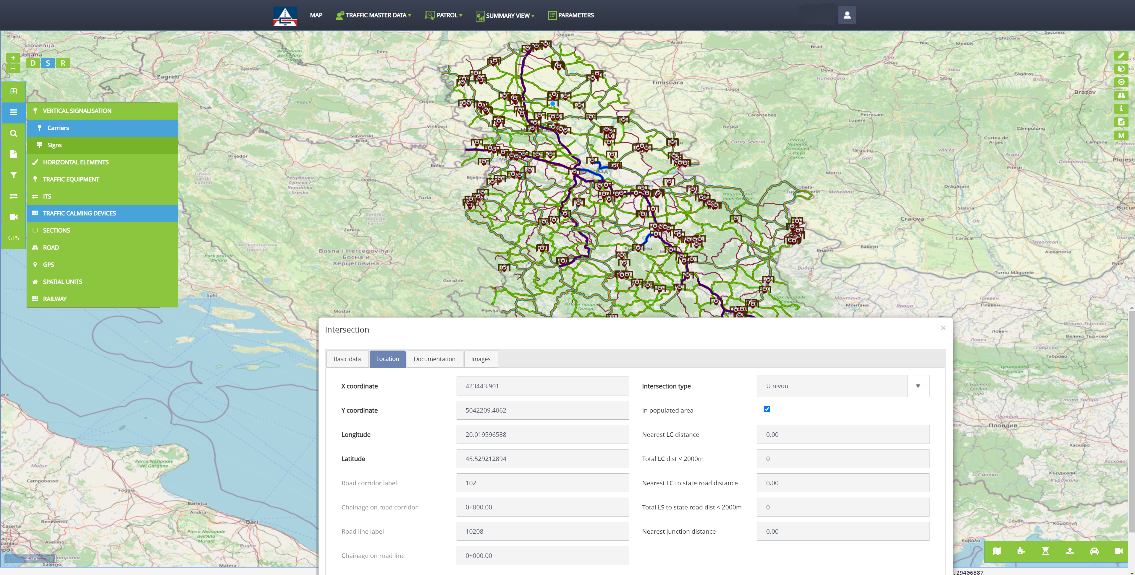
The Traffic Signal and Equipment Database contains data recorded as part of a pilot project on 100 km of state roads. In the pilot area, LIDAR technology was used to record in 2019, so that spherical photo data and a 3D terrain model are also available.
The Level Crossing Database contains data on level crossings on state roads, which was obtained by cross-referencing, matching and checking data from various relevant sources. The sources are: railway operating companies, supervisory authorities supervising state roads, data collected using LIDAR technology as part of pilot projects in 2019 and 2020 at 43 level crossings, field visits to individual level crossings in 2019-2022, the RRSP-RNCS state road network survey project in 2017-2020, inventory sheets from 2021. The data is regularly updated at periodic intervals. Working with data from both databases is enabled through a single WEB application software that serves for visualization, spatial analysis, creation of interactive reports, viewing spherical photos and 3D terrain models, etc.
The Database on Traffic Accidents on state roads was established for the purpose of monitoring the state of traffic safety, as well as monitoring the effects of the measures implemented in the process of improving traffic safety on the state road network. In order to improve the quality of data, qualitative and logical control is carried out. The data is collected by the Ministry of Interior, which distributes the master database on traffic accidents to the Traffic Safety Agency. The Traffic Safety Agency delivers this data to the PE “Roads of Serbia” through the established data exchange service.
The Central Geospatial Database contains various types of spatial data, with each data class described by a set of specific attributes. For the purpose of forming the geospatial database, real-world objects were georeferenced, which are displayed in the form of points, lines and polygons. The data were obtained from various sources, such as other specialized databases, various alphanumeric databases, as a result of projects and studies conducted within the PERS, by collecting data in the field using GPS as well as other dedicated devices and sensors for recording various values and indicators. The dynamics of data update varies depending on the type of data, with some updating is done periodically for a certain number of days or months, while with others it is done in real time by directly sending data from the measuring device.
The GIS portal of the Public Enterprise “Roads of Serbia” is a WEB application that enables centralized and comprehensive insight into data from the central geospatial database of the Public Enterprise through visualization of content on a single interactive map, with the possibility of applying various spatial analyses, searches, overlapping of different data types, generating reports, etc. Since the central database stores data from specialized (native) databases, the most important data on the PERS GIS portal can be viewed on: the state road reference system, traffic counting, axle load, road network condition assessment, road objects, unstable phenomena, level crossings, ITS equipment elements, toll stations, accompanying public road facilities, bicycle paths, traffic accidents, data from various projects and studies conducted within the PERS, road maintenance territories, energy management, the European Road Network, the register of spatial units, organizational units of the Ministry of Internal Affairs, as well as an ortho-photo of the Republic of Serbia.
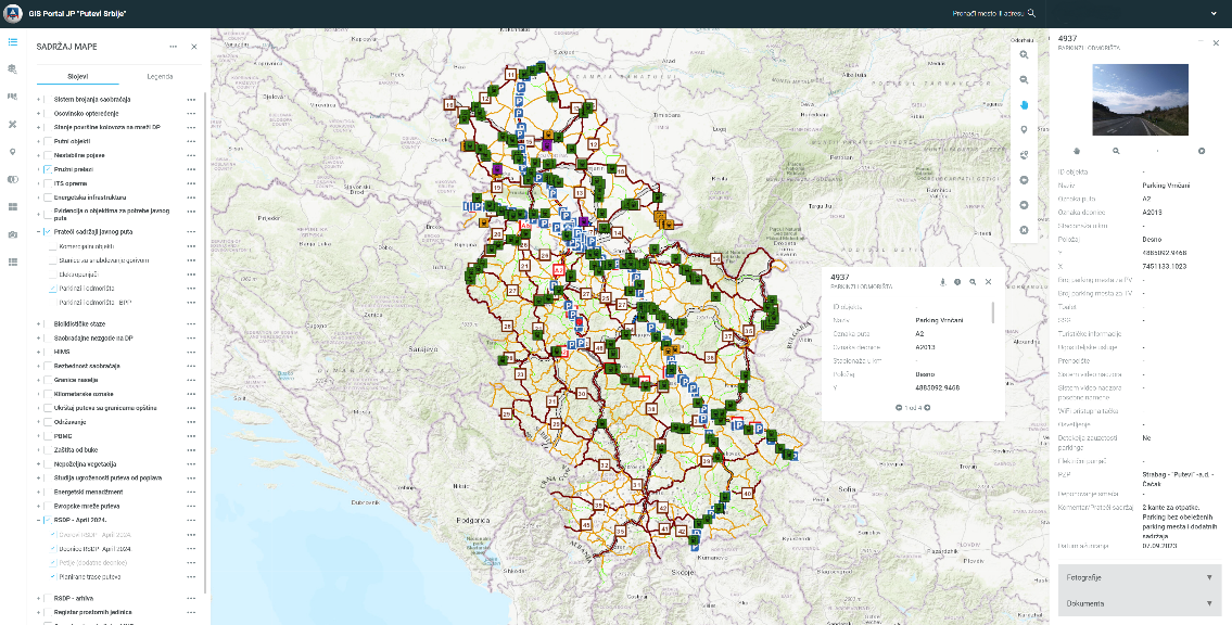
For the purpose of presenting data to the general public, a special version of the GIS portal of the Public Enterprise "Roads of Serbia" has been created with limited content of interest to the general public. Access for the general public is enabled through the official website of the PERS.
In addition to the development and management of databases, the Database and GIS Department also carries out other important activities such as:
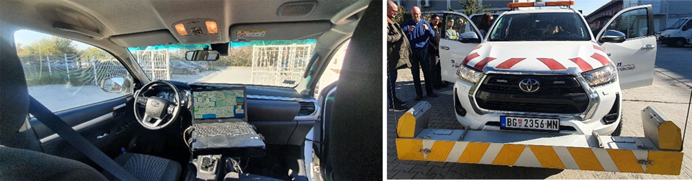
The Database and GIS Department collects data on the functional properties of the road surface. Data collection includes activities of recording the longitudinal and transverse evenness of the road using DYNATEST road network recording equipment installed on a specialized vehicle. The collected data is processed and entered into the central database, and then further presented within the GIS portal of the Public Enterprise "Roads of Serbia".
Providing support to other organizational units and sectors in business process automation projects, as well as data preparation and analysis activities for the implementation of various business tasks.
Participation in important projects
Representatives of the Database and GIS Department participate in many working groups and teams during the implementation of various projects, the most significant of which are:
- Cooperation with the Republic Geodetic Authority with the aim of forming the National Geospatial Data Infrastructure and data meta-catalogs;
- Participation in the project called - "DANUBRIDGE-CONNECT", the project is led by the company “Croatian Roads” with the aim of analyzing and comparing the results of border bridge inspections in a classic way and a modern way (by drone);
- Participation in the process of harmonization and harmonization of the INSPIRE directive with legal and by-laws in the Republic of Serbia;
- Cooperation with the Secretariat of the Transport Community in order to provide the necessary data for the implementation of the TODIS project and for updating the TODIS database (Transport Observatory Database / Information System);
- Cooperation with the Traffic Safety Agency and the Traffic Police Directorate of the Ministry of Internal Affairs in the development and updating of the Unified Database on the Basic Characteristics of Traffic Safety;
- Project Development of a National Transport Development Strategy in the Republic of Serbia for the period until 2030;
- Educational campaigns to raise awareness about traffic safety:
- „3 seconds a lifetime“
- „Do not drive in the emergency lane“
- „Do not block the emergency lane, do not block life“
- „Do not destroy the traffic sign - The sign means life“
- „Safely through the tunnel“
- „We are not alone in the tunnel“;
- Drafting the Regulation on the method of crossing the railway and the road, pedestrian or bicycle path, the place where the crossing can be carried out and measures to ensure safe traffic;
- Cooperation with the Ministry of Construction, Transport and Infrastructure, Railway Infrastructure and the Railway Directorate regarding application software for working with data from the geospatial database on traffic signals and level crossings;
- Providing proposals for amendments and supplements to the Law on State Roads;
- Harmonization of the TEN-T Network with the new version of the Reference system of the state roads.