


Expropriation for the reasons of motorway and fast roads construction in the Republic of Serbia
Sector for Legal, Staff and Common Affairs of the PE “Roads of Serbia” has, in the period from September 2008 until today, completed the procedures of expropriation which enabled the construction of the motorways and fast roads in the length of 600 km in total.
Sections with the completed expropriation:
Corridor 10
Motorway E-75 ( Grabovnica – border with the Republic of North Macedonia – 97.4km )
1. Grabovnica – Grdelica – 7.9km
2. Grdelica – Caričina Dolina – 12km
3. Caričina Dolina – Vladičin Han – 14.3km
4. Vladičin Han – Donji Neradovac – 26.2km
5. Donji Neradovac – Srpska Kuća – 6km
6. Srpska Kuća – Levosoje – 10km
7. Levosoje – Bukarevac - 10.3km
8. Bukarevac – border with the Republic of North Macedonia – 10.7km
Motorway E-80 ( Niš – border with the Republic of Bulgaria –108.1km )
1. Prosek – Crvena Reka – 22.5km
2. Crvena Reka – Čiflik – 12.6km
3. Čiflik – Staničenje – 12.2km
4. Staničenje – Pirot East – 14km
5. Pirot East – Sukovo – 7km
6. Sukovo – Dimitrovgrad – 8.8km
7. Dimitrovgrad bypass – border with the Republi of Bulgaria – 8.7km
8. Parallel (non-commercial) road from Bela Palanka to Pirot – 22.3km
Motorway E- 75, Belgrade bypass – border with the Republic of Hungary
1. Belgrade bypass, Batajnica – Dobanovci – 10.5km
2. Belgrade bypass, Sector 5 – 5.5km
3. Kelebija – Subotica (Y branch) – 24km
4. Novi Sad bypass – 12km
5. Horgoš – Novi Sad ( expropriation on the territories of Novi Sad, Mali Iđoš, Vrbas, Subotica and Kanjiža from km 0 to km 108 is yet to be completed)
6. Interchanges between Novi Sad and Belgrade ( Stara Pazova, Inđija, Kovilj, Beška and Maradik )
Motorway "Miloš Veliki"– 120km
1. Novi Beograd – Surčin - 8km
2. Surčin – Obrenovac - 17,6km
3. Obrenovac – Ub - 24km
4. Ub – Lajkovac - 12,5km
5. Lajkovac – Ljig - 26km
6. Preljina – Požega - 32km
Other sections:
1. Valjevo – Lajkovac - 18km
2. Kuzmin – Sremska Rača - 18km
3. Ruma – Novi Sad - 18km
4. Novi Pazar – Tutin - 18km
5. Šabac – Loznica - 55km
6. Bogatić – granica sa BiH - 8km
7. Niš – Merdare - 78km
8. Gornji Milanovac – Takovo - 5km
9. Lapovo – Batočina - 5km
Ukupno: 223km
The procedure of expropriation is carried out exclusively in authorized offices of property and legal affairs in municipalities and cities through which the future motorway will pass. PE “Roads of Serbia”, as the beneficiary of expropriation, begins the procedure by submitting the proposal for expropriation.
The administrative body of the municipality informs the parties on the commencement of the expropriation procedure and brings decisions on expropriation. As soon as the decision on expropriation becomes valid, the PE “Roads of Serbia” is in obligation to submit a written offer concerning the method of payment and the amount of compensation for the expropriated property.
The tax administration office determines the amount of compensation for the land, while experts of relevant profession determine the amount of compensation for plants and structures. The agreement on compensation is signed before the competent municipal court.
SECTOR FOR LEGAL, STAFF AND COMMON AFFAIRS
Executive director
Goran Tomić, LL.B.
**Note: Information on the dynamics of expropriation for the reasons of motorway construction in the Republic of Serbia was published on 25.11.2021 and shall be valid until new information is published.
Department for Planning Documentation
The Department for Planning Documentation organizes, coordinates and performs the preparation, development and implementation of the Program for the Preparation of Planning Documentation.
It also processes cases related to issuing conditions for the development of the Program for Spatial and Urban Planning Documentation.
The Department also prepares tender documentation and is involved in the public procurement processes for the preparation of planning documentation. Based on active contracts, it monitors the contractor’s schedule, the contractor’s implementation progress and reviews their payment certificates for the fulfillment of contractual obligations.
The Department performs and monitors the implementation of all necessary conditions, opinions and approvals required for the preparation of planning documentation. It prepares and obtains decisions, opinions and conclusions related to the implementation of the necessary planning documentation for the project implementation.
The Department participates in, monitors and involves its personnel in the work of expert commissions and teams for evaluating final planning documentation.
ACTIVITIES OF THE DEPARTMENT RELATED TO PLANNING DOCUMENTATION:
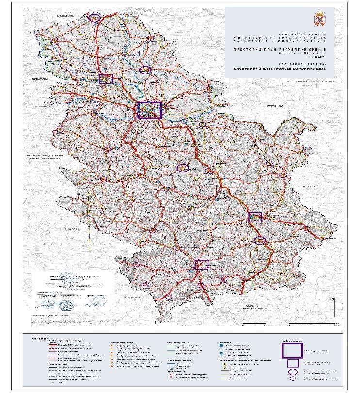
As part of its regular activities, the Department works on the implementation of all spatial plans of infrastructure corridors for all construction projects. The Department actively supports the preparation of the Draft of the new Spatial Plan of the Republic of Serbia for the period 2021-2035, whose adoption is expected soon.
Monitoring of the planning documentation preparation and coordination between designers and expert supervisors. Monitoring of the commercial contract implementation processes, which include coordination between financiers and contractors in the segment related to planning documentation development.
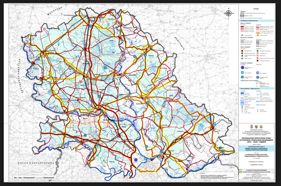
Adoption of the Regional Spatial Plan of the Autonomous Province of Vojvodina for the period 2021-2035 and the Report on the Strategic Environmental Impact Assessment of the Regional Spatial Plan of the Autonomous Province of Vojvodina are currently underway.
In addition to these tasks, the Department is also responsible for:
- Issuing conditions for the preparation of planning documentation for spatial and urban plans on the territory of Serbia.
- Issuing conditions during the revision of planning documents.
- Issuing conditions for the preparation of urban designs/land parcellation, re-parcellation and installation layouts. Issuing location conditions for locations within the corridors of structures under the jurisdiction of PE “Roads of Serbia”.
- Issuing conditions for the preparation of Urban Planning Requirements for specific locations and their connection to transport infrastructure.
- Issuing conditions for planning and urban planning and technical documentation
REQUIRED DOCUMENTATION FOR ISSUING CONDITIONS FOR THE PREPARATION OF PLANNING AND URBAN AND TECHNICAL DOCUMENTATION
https://www.putevi-srbije.rs/index.php/sr/izdavanje-uslova-za-planska-dokumenta
Correction of cadastral parcel boundaries (in accordance with the valid planning basis)
Submission of requests for the issuance of Extracts from the Plan for the construction of road routes for the needs of PE “Roads of Serbia“.
Organization of public presentations of major key projects, in cooperation with the Serbian Chamber of Engineers, the Road Association of Serbia and commerce chambers.
The following planning documentation currently under development are listed below:
- Spatial Plan of the special purpose area of the infrastructure corridor Belgrade – South Adriatic, section Požega – Boljare (border with MNE), with the Strategic Environmental Impact Assessment
- Detailed Regulation Plan for the construction of the road (bypass) on the route from the motorway E75 (interchange North) Novi Sad – Veternik – Futog – Begeč – Gložan – Čelarevo – Bačka Palanka
- Detailed Regulation Plan for the reconstruction and construction of the interchange Maradik on the state road IA-A1 (E-75)
- Spatial Plan of the special-purpose area of the infrastructure corridor for the construction of the IB category expressway, Paraćin – Zaječar – Negotin, L = 140km
- Spatial Plan of the special-purpose area of the infrastructure corridor of the IB category expressway, motorway E-75 Belgrade-Niš (interchange Požarevac) – Požarevac (Bypass) – Veliko Gradište – Golubac
- Spatial Plan of the special-purpose area of the infrastructure corridor for the construction of the IB category expressway on the routes Golubac – Donji Milanovac – Brza Palanka
- Detailed Regulation Plan (L = 51 km) for the construction of the IB category expressway Šabac – Loznica, L = 55 km and Slepčević – border crossing Badovinci (Pavlovića Bridge), L = 15 km
- Spatial Plan of the special-purpose of the infrastructure corridor for the construction of the IB category expressway, Kraljevo – Ušće – Raška – Novi Pazar
- Planning-technical documentation for the construction of the IB category expressway, Ostružnica, L = 20km
- Detailed Regulation Plan for the reconstruction and construction of the IIA category state road no.102, Novi Sad – Temerin with Bački Jarak and Temerin bypasses, L=15.0km
- Planning-technical documentation for the construction of the bypass around Vlasotince (L = 7km)
- Planning-technical documentation for the construction of Bašaid and Melenci bypasses (L = 12km)
- Planning-technical documentation for the construction of the northwestern bypass of Novi Pazar
- Planning-technical documentation for the construction and reconstruction of the IIA category state road no.223, from the monastery Poganovo to Zvonce, L = 12.0 km
- Planning-technical documentation for the construction and reconstruction of the IIA category state road no.197, Kaona – Ivanjica, section: Dubac – Luke, L = 11.0km
- Planning documentation for the construction of the IIA category state road no.130 bypass around Orlovat, including the road bridge over the river Tamiš
- Urban-technical documentation and technical documentation for demolition and construction of a bridge over the South Morava River on the IB category state road no.39, sections: Vlasotince – Leskovac
- Planning and technical documentation for the construction of a bridge over the West Morava River on the IIA category state road no.189, section Selište (West Morava) – Stopanja (West Morava)
- Technical documentation for the reconstruction of the viaduct over the gorge - KOMINJSKE BARE – on the IB category state road no.22, section Novi Pazar (Brđani) – Ribariće
- Urban-technical documents and technical documentation for relocating part of the alignment of the IIA category state road no.154 and construction of an overpass over the Belgrade – Požarevac railway line
- Urban planning design for the reconstruction of the IIA category state road no.100, section: through the settlement Sremski Karlovci, km 132+369 - 135+580, L = 3.21 km
Planned planning and technical documentation for the upcoming period:
- Planning-technical documentation for the expansion of the border crossing Batrovci
- Planning-technical documenation for the expansion of the motorway А1 (Е75) on the section from Belgrade to Novi Sad
- Spatial Plan of the special-purpose area of the infrastructure corridor of the Belgrade Bypass – Sector C
- Detailed Regulation Plan (L = 51 km) for the construction of the IB category expressway Šabac – Loznica, L = 55 km and Slepčević – border crossing Badovinci (Pavlovića Bridge), L = 15 km
- Spatial Plan of the special-purpose area of the infrastructure corridor for the IB category expressway, motorway E-75 Belgrade-Niš (interchange Požarevac) – Požarevac (Bypass) – Veliko Gradište - Golubac
- Spatial Plan for the special-purpose area of the infrastructure corridor and Feasibility Study with the Preliminary Design for the construction of the IB category expressway Paraćin – Zaječar – Negotin, L = 140km
- Planning-technical documentation for the construction of the IB category expressway, Ostružnica – Obrenovac, L = 20km
- Spatial Plan of the special-purpose area of the infrastructure corridor for the construction of the IB category expressways on the route Golubac – Donji Milanovac – Brza Palanka
- Spatial Plan of the special-purpose area of the infrastructure corridor for the construction of the IB category expressway Kraljevo – Ušće – Raška – Novi Pazar
- Urban planning designs for defining public interest for constructing functional facilities – road maintenance bases along the expressways Požarevac – Golubac and Šabac – Loznica
- Amendments to the Spatial Plan of the special-purpose area of the infrastructure corridor of the I category state road no.21 Novi Sad – Ruma – Šabac and the I category state road no.19 Šabac-Loznica
- Planning-technical documentation for the construction of the Senta bypass
- Planning-technical documentation for the construction of the northern bypass around Valjevo
- Planning-technical documentation for the widening of roads (IB category state road no.23) accessing the border crossing Gostun
- Detailed Regulation Plan for the reconstruction and construction of the IIA category state road no.153 Leštane – Smederevo
- Detailed Regulation Plan for the reconstruction of the road-rail bridge over the river Danube – Pančevo Bridge in Belgrade, on the IB category state road no.47, section Belgrade (Bogoslovija) – interchange Krnjača and the construction of access ramps

